
A weekend marked by storms and falling temperatures is looming. Beware of precipitation, some departments are to be monitored.
In the French sky, summer seems to be coming to an end. The rain is also making its comeback after a particularly short vacation. This weekend, at The image of the last few days, is marked by the presence of a low pressure system, with the program of falling temperatures, rain, and thunderstorms in some places. Since Tuesday, half of the country has been affected by the “storm, rain and flood” alert &issued by Météo France, and although in sharp decline, the country will still be cut in two this weekend, with instability on one side, and on the other drier weather punctuated by beautiful clearings.
At the end of the week, the depression present over the Bay of Biscay continues to bring unstable weather to the entire country. The bad weather is concentrated in the eastern half, from the Ardennes to the Gard, as well as in the extreme southwest. The departments bordering Switzerland are particularly subject to significant accumulations of rain until Friday. In Corsica, the weather is also particularly capricious, while in the north-west and centre-west regions, the risk of showers is more limited.

© La Chaine Weather
In terms of temperatures, this weekend marks the end of the heat wave that has been present across the country since the start of the Paralympic Games. Thursday and Friday are already announced as the coolest days of the week with an average of 17°C, or three degrees less than at the start of the week. Locally, this drop in temperature is less marked. In the northern half, it is difficult to exceed 20°C in the afternoon, while in the Mediterranean basin, several departments still benefit from an average of around 25°C. The overall trend indicates a drop below seasonal norms and the end of tropical nights.
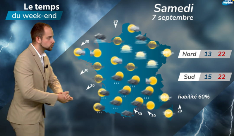
For the weekend, the trend does not seem to be reversing, although meteorologists have not yet provided any guarantees regarding reliability. For Saturday, La Chaine Météo predicts "threatening and stormy weather in the south" and "beautiful és spells with generally seasonal temperatures" for the north. On Sunday, the depression continues and moves up towards the northeast.
The Mediterranean basin risks experiencing new storms while the northeast and southwest should be spared from the bad weather, despite the presence of some clouds. The temperatures forecast are rising slightly in the northern half with 23 to 25°C, in the east, the Paris basin and the north. In the south, however, they continue to fall due to the risk of thunderstorms. Also be aware of the risk of flooding in the event of thunderstorms.