
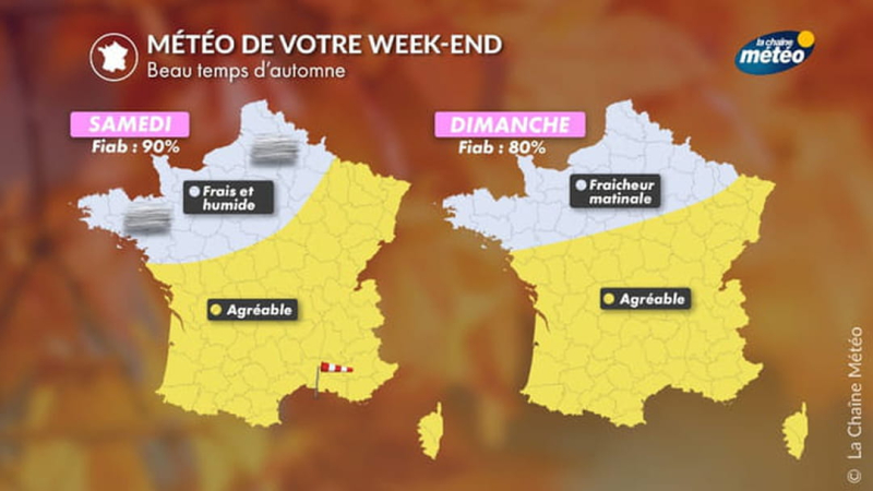
The cold remains but the sun returns to part of France this weekend end. Significant variations are to be expected, with temperatures potentially doubling. This year, autumn is a little early. Since Tuesday, France has been crossed by a mass of polar air that extends over most of the country. But from Friday, the gusts of wind sweeping the south and the few rather stormy showers present in the northern half should weaken and give way to sunshine for the entire weekend. The cold will continue with temperatures expected to be very low for the season, even if we are far from the previous records of freshness. Saturday is marked by the improvement coming from the south of France thanks to the Açores anticyclone. The sun dominates over the whole country with the exception of the departments of the East of France, where a few scattered showers could occur. A sign of the freshness that is spreading in France, the first white frosts are however at expected in the morning, especially in the Centre-Val de Loire and the Auvergne region. And in the south, the mistral and the tramontane are starting to run out of breath. © The Weather Channel Temperatures remain cool, between 3 and 8°C over three-quarters of the country. Only the departments around the Mediterranean manage to reach 13 to 15°C in the morning. In the afternoon, all departments will gain 10°C to 15°C. 12°C more than in the morning, except in Corsica with only 8°C more, La Chaine Météo predicts 22°C on the Isle of Beauty and up to 25°C along the coasts of the Mediterranean. On Sunday, the wind will continue to weaken in the southeast. After the fog passes in the morning over the northern half, a few clouds will form over the northeast quarter of the country, between Lille and Dijon. Over the rest of the country, a clear and bright sky is expected. Despite the freshness that persists once again, Sunday will be generally more pleasant, with temperatures slightly higher than the day before. In the morning, the thermometer will display 10 to 15°C on the Île-de-France, the Atlantic coast and the south-east quarter, but for the rest of the country, we should expect find temperatures rather around 4 to 8°C. The afternoon should be similar to the day before, with clear skies over the western half and the south-east. Similarities also in terms of temperatures with 17 to 20°C in the northern half and up to 25°C in the south, between Perpignan and Nice. Overall, temperatures will be highest near the coast. But be careful, the wind will not have disappeared, especially in the south. It is a rather calm and sunny weekend that is looming on the horizon and that we will have to take advantage of because Monday marks the return of cloudy weather from east to west with a resurgence of mistral in the southeast. On the coast temperature, the heat present in the south rises in the center of the country and along the Atlantic coast. Monday, the minimums are for Rennes and Aurillac with 8°C in the morning and 18°C in the afternoon and the maximums for Perpignan and Montpellier with 16°C and 26°C.
From single to double: Temperatures will yo-yo across much of the country this weekend
ByTeilor Stone
Sep 13, 2024
By Teilor Stone
Teilor Stone has been a reporter on the news desk since 2013. Before that she wrote about young adolescence and family dynamics for Styles and was the legal affairs correspondent for the Metro desk. Before joining Thesaxon , Teilor Stone worked as a staff writer at the Village Voice and a freelancer for Newsday, The Wall Street Journal, GQ and Mirabella. To get in touch, contact me through my teilor@nizhtimes.com 1-800-268-7116