© Maria Orlova/Pexels
In the heights of the Caucasus, the tall summer grass jealously guarded a secret dating back to the Bronze Age. It was not until autumn, when the vegetation had receded, that archaeologists glimpsed the true extent of their discovery. The site of Dmanisis Gora, a three-millennia-old fortress nestled in the Georgian mountains, turned out to be an architectural complex of exceptional magnitude.

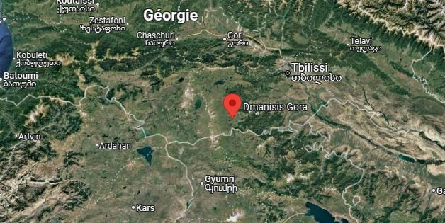
Dmanisis Gora is an archaeological site located in southern Georgia, in the Kvemo Kartli region. © Screenshot/Google Maps
A sleeping giant revealed from the air
The initial excavations, initially carried out by an international team of archaeologists from Georgia, Great Britain and the USA, had not allowed to glimpse only a tiny part of the site. The real revelation came from the sky, thanks to the deployment of drones equipped with high-precision photogrammetric sensors.
By combining aerial photography and digital modeling, archaeologists were able to reconsider the size of the building, which turned out to be absolutely colossal. The fortress covers a staggering area, exceeding the researchers' initial assumptions by forty times. The most spectacular feature remains its defensive wall, a masterpiece of ancient engineering that winds for a kilometer through the mountainous landscape of the Caucasus.
This monumental enclosure protects a veritable labyrinth of dwellings, community structures and stone developments, revealing a society that mastered the art of urban planning 3,000 years BCE.
Dmanisis Gora finally reveals its secrets
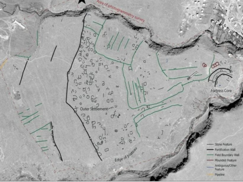
Professor Nathaniel Erb-Satullo of the Cranfield Forensic Institute and his team took nearly 11,000 aerial photographs. These images, assembled into digital elevation models and orthophotos (straightened aerial photography, removing distortions related to relief), made it possible to identify the smallest details of the terrain: “These data sets allowed us to identify subtle topographical features and create precise maps of all the fortifications, tombs, agricultural systems and other stone structures within the outer wall ,” Erb-Satullo explains.
200% Deposit Bonus up to €3,000 180% First Deposit Bonus up to $20,000During the Cold War, American spy satellites photographed this region of the Caucasus, producing remarkably precise images. These images, long classified as top secret and then declassified in 2013, thus gave researchers a detailed aerial view of the site as it was fifty years ago. By superimposing these old photographs on current drone surveys, archaeologists can accurately measure the impact of modern agriculture on the preservation of the remains.

Map of Dmanisis Gora Fortress showing the fortified core, outer residential areas, fortification and boundary walls, as well as stone structures, fields agricultural and raised elements. © N. Erb-Satullo
The architectural analysis of Dmanisis Gora is proof that it was based on a particularly urbanization model sophisticated for the Bronze Age. Archaeologists have highlighted a modular housing system, where urban space was transformed at the pace of pastoral migrations . ” The outdoor establishment could expand or contract according to the seasons », explains Dr Erb-Satullo, describing a process of flexible urbanization, quite rare at this time.
This architectural adaptability responded to a social reality: during the summer months, nomadic groups converged on the fortress with their herds, establishing semi-permanent camps within the outer enclosure. These spaces, delimited by the perimeter wall, then hosted a lively tangle of temporary dwellings, livestock enclosures and trading areas. In winter, when the shepherds returned to the plains with their animals, these same spaces were partially emptied, retaining only a reduced permanent population.
This unique configuration demonstrates remarkable urban planning intelligence: the builders of Dmanisis Gora had designed a city capable of absorbing considerable demographic variations, while maintaining its defensive and administrative functions. The scientific teams are now continuing their investigations to better understand the dynamics inherent in the population density, livestock movements and agricultural practices of this fortress city. If there is one lesson to be learned from this story, it is that drones give us technical superiority in many areas, archaeology is no exception.
- A gigantic ancient fortress has been discovered in the Caucasus thanks to drones, revealing a much larger architecture than expected.
- The site shows flexible urbanization, adapted to the seasonal migrations of pastoral groups 3,000 years ago.
- This discovery opens up unique perspectives on the interactions between sedentary and nomadic societies in the Bronze Age.
📍 To not miss any Presse-citron news, follow us on Google News and WhatsApp.
[ ]

