
If the bad weather associated with the Kirk depression weakens this Thursday, six departments remain on orange alert and one on red alert for flooding. Thunderstorms could break out north of the Loire and in Normandy.
The essentials
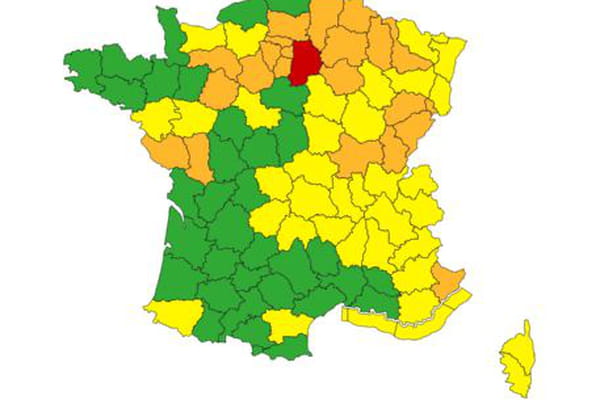
- This Thursday morning, storm Kirk is coming to an end, but 6 departments remain on orange alert and one, Seine-et-Marne, is placed on on red alert for floods by Météo France in its latest 6 a.m. bulletin.
- In the morning, the disturbance will move away through the eastern borders of France, even if the weather should remain unsettled in Corsica this morning. "South-westerly winds are blowing at 60/70 km/h and up to 100 km/h on the Corsican relief”, specifies Météo France.
- In the rest of the country, showers will locally take on a stormy character north of the Loire from this afternoon. Showers will be frequent in the west of the Massif Central and in the Basque Country, where they can give local accumulations of up to 40 mm.
- The distribution network manager Enedis indicated that 67,000 homes were without electricity. Among them, 35,000 are in the Pyrénées-Atlantiques.
- On the Mediterranean coast, the storm caused a strong swell and caused the death of a yachtsman off the coast of Sète (Hérault), “a 70-year-old resident of the commune whose sailboat capsizedé", specifies France Bleu.
- The Windy application models meteorological data and allows you to visualize storm Kirk and its progression. Here you can see the wind gusts and their evolution.
Live
08:19 – Gusts up to à 140 km/h on Cape Corsica
In Corsica, the weather will remain unsettled this Thursday morning. Moderate rain is expected to fall on the western side of the island and southwest winds will blow at 60/70 km/h and up to 100 km/h on the Corsican relief. “This afternoon, the wind will strengthen significantly from 2 p.m. and blow in strong gusts at “90-100 km/h on the Balagne and between 100 and 120 km/h on the Cap Corse”, specifies Météo France. Gusts up to 130 km/h are even expected in the mountains on the southern part of the island, on the ridges “and violent gusts between 100 and 110 km/h in the Solenzara and Porto-Vecchio areas. This evening, the wind peak will be reached with gusts of 130-140 km/h on Cap Corse", concludes the weather station.
08:13 – Seine-et-Marne on red alert this Thursday
This Thursday morning, six departments have been placed on orange flood alert by Météo France: Vendée, Deux-Sèvres, Orne, Sarthe, Eure-et-Loir and Meurthe-et-Moselle. The weather station also places, as it has since late Wednesday, the Seine-et-Marne department on red alert, also for floods.
Pour jeudi 10 octobre 2024 :
🔴 1 département en Vigilance rouge
🟠 6 départements en Vigilance orangePour vendredi 11 octobre 2024 :
🔴 1 département en Vigilance rouge
🟠 6 départements en Vigilance orangeRestez prudents et informés :https://t.co/JGz4rTUvHP pic.twitter.com/UVtxdI3c6H
— VigiMétéoFrance (@VigiMeteoFrance) October 10, 2024
09/10/24 – 23:36 – "The biggest accumulation [of rain] of a “autumn day since 1920” recorded in Paris
END OF LIVE – Images of France hit by heavy rainfall this Wednesday have been numerous. While flooded fields or streets in Noirmoutier under water have been widely relayed, Paris is not left out. As meteorologist Guillaume Séchet indicates on X, the capital has recorded 65 mm of rain since Wednesday morning. This is “the highest accumulation of one autumn day since 1920!” he assures.
🌧️ Images insolites de l'Assemblée Nationale inondée ce soir du 9 octobre 2024 ! #Paris enregistre 65 mm de #pluie depuis ce matin, soit le plus gros cumul d'une journée d'automne depuis 1920 ! https://t.co/IlmZNwnzqo
— Guillaume Séchet (@Meteovilles) October 9, 2024
09/10/24- 23:03 – 26 departments still on alert on the night of Wednesday to Thursday

In addition to the Alpes-Maritimes, still on orange alert for rain-flooding and flooding, Météo-France is keeping 24 other departments located in the northern half of France on orange alert for various reasons: rain-flooding, flooding and wind. Seine-et-Marne remains on red alert. However, most alerts should be lifted during the night. The end of the rain-flood alert is announced for 3 a.m. on Thursday, while the one concerning winds runs until 6 a.m. On the other hand, flood warnings should not be lifted immediately because, as we know, it takes some time for rainwater to drain away.
09/10/24- 22:38 – The National Assembly “is taking on water!”
Several MPs, including the one from the Somme, François Ruffin, have issued Wednesday night, images and videos of water seeping into one of the National Assembly buildings as Storm Kirk continues to sweep across the country.
Après le gouvernement, c'est l'Assemblée qui prend l'eau ! pic.twitter.com/ecySwZCByZ
— François Ruffin (@Francois_Ruffin) October 9, 2024
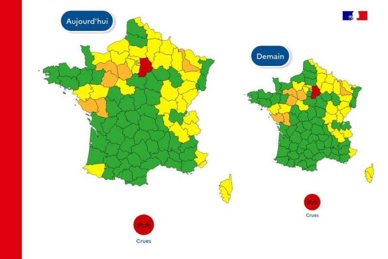
In its latest evening bulletin, Météo-France announces the end of the rain-flood alert in five departments: Sarthe, Indre-et-Loire, Loir-et-Cher, Eure-et-Loir and Loiret. On the other hand, several departments have been placed on orange alert for floods. This is particularly the case for Deux-Sèvres, Orne, Sarthe and Eure-et-Loir. This Wednesday evening, there are still 28 departments on orange alert and one, Seine-et-Marne, remains on red alert.
Pour mercredi 09 octobre 2024 :
🔴 1 département en Vigilance rouge
🟠 28 départements en Vigilance orangePour jeudi 10 octobre 2024 :
🔴 1 département en Vigilance rouge
🟠 25 départements en Vigilance orangeRestez prudents et informés :https://t.co/JGz4rTUvHP pic.twitter.com/tDAFu4Usxb
— VigiMétéoFrance (@VigiMeteoFrance) October 9, 2024
09/10/24 – 21:37 – How many departments are still on alert on Thursday ?
If around thirty departments are still on orange alert for the most part – only Seine-et-Marne is on red – this Wednesday evening, what will happen tomorrow ? In its latest bulletin, Météo-France indicates that on Thursday, 21 departments will be on orange alert and one on red alert. The rain-flood alert concerning Île-de-France and Champagne-Ardenne should however be lifted on 3 a.m. while the wind warning, which extends from Saône-et-Loire to the Territoire de Belfort, should end around 6 a.m.
09/10/24 – 21:04 – Train traffic severely disrupted by storm Kirk
The SNCF updated this evening the disruptions that occurred on Wednesday on the railway lines. The passage of storm Kirk caused a complete interruption of traffic on several lines in Nouvelle-Aquitaine. In the Pays de la Loire, flooding is the cause of traffic interruptions on three lines, while in the Rhone-Alpes region, falling trees and strong winds are the cause. Heavy rainfall and again strong winds are being blamed for line P in Île-de-France.
⚠️INFORMATION VOYAGEURS
Mise à jour sur les perturbations de nos lignes ferroviaires en Nouvelle-Aquitaine, Pays de la Loire et Île-de-France en raison de la tempête Kirk. Dans la région Rhône-Alpes, la circulation est perturbée en raison de chutes d'arbres et de vents violents.… https://t.co/QxmhjCM9ns pic.twitter.com/a2Hw0udYmn— SNCF Voyageurs (@SNCFVoyageurs) October 9, 2024
09/10/24 – 20:27 – More than 64,000 homes without electricity Wednesday evening at 7 p.m.
According to Enedis, 35,000 homes located in the Pyrénées-Atlantiques were without electricity early Wednesday evening. There were also 8,000 in Landes, 7,500 in Ariège, 4,500 in Gers, 4,400 in Rhone, 2,100 in Loire, but also in Ain, and 500 in Hautes-Pyrenees, i.e. a little over 64,000 affected households.
A storm has been sweeping across French lands since Wednesday, October 9. Hurricane Kirk, which is developing in the middle of the Atlantic Ocean, has been downgraded in category 1/5, continues to weaken to become an extratropical storm, and it is this storm Kirk that is blowing over France from west to east between this Wednesday and Thursday according to the weather forecast.
Storm Kirk is hitting the Bay of Biscay from this Wednesday and will affect a large northwest quarter before gradually sliding towards the northeast. The depression should follow a diagonal axis going from Vendée, in the Pays de la Loire, to Lorraine, in the Grand Est.
Météo-France has placed 6 departments on orange alert for Thursday: Vendée, Deux-Sèvres, Orne, Sarthe, Eure-et-Loir and Meurthe-et-Moselle for "floods". And one on red alert, also for "floods": Seine-et-Marne, by Météo France.
Strong winds in Corsica
In Corsica, the weather will remain unsettled this Thursday morning. Moderate rain is expected to fall on the western side of the island and southwest winds will blow at 60/70 km/h and up to 100 km/h on the Corsican relief. “This afternoon, the wind will strengthen significantly from 2 p.m. and blow in strong gusts at “90-100 km/h on the Balagne and between 100 and 120 km/h on the Cap Corse”, specifies Météo France. Gusts up to 130 km/h are even expected in the mountains on the southern part of the island, on the ridges “and violent gusts between 100 and 110 km/h in the Solenzara and Porto-Vecchio sectors. This evening, the wind peak will be reached with gusts of 130-140 km/h on Cap Corse", concludes the weather station.
The winds generated by Storm Kirk are expected to be the main hazard, which could cause trees or objects to fall. In case of vigilance, it is recommended to protect your home and to secure or bring in any outdoor objects likely to be blown away. It is also preferable to limit your movements and to stay informed of the situation via the authorities. The risks are even greater when heavy rains are added to the strong winds.
Météo France
Showers on the Massif Central and the Basque Country
In Seine-et-Marne, the red alert for “floods” can have several consequences. Very significant floods are possible, including in areas that rarely flood, traffic conditions can be made extremely difficult on the entire road or rail network, power cuts longer or shorter periods can occur, but also phenomena of rupture or overflow of dikes can occur.
In the rest of the country, a noticeable westerly wind is established in most regions, the trailing sky is active and gives showers which locally take on a stormy character north of the Loire in the afternoon. Showers are also more frequent in the west of the Massif Central and in the Basque Country, where they can give local accumulations of up to 40 mm. On the Mediterranean coast, the wind blows in gusts of up to 60 to 80 km/h near the Mediterranean, clearing the sky.
“Storm Kirk will evacuate towards Germany and we will find less agitated weather over France. The clouds will remain numerous, accompanied by showers from the southwest to the northeast. A few strong gusts could still occur early in the morning in the Grand Est region. Mistral and tramontane will rise in the Mediterranean, specifies La Chaine Meteo. At 6:10 this Thursday morning, precipitation readings carried out by Meteo France indicate 80mm at Montigny le Bretonneux (78), 79 mm at Noirmoutier (85), 73 mm at Nantes (44), 70 mm at Paris-Montsouris (75) and it fell very locally 120 to 130 mm on the Alpes Maritimes.