
The storms linked to Storm Kirk are finally over, but six departments remain on flood watch this Friday, October 11, including two in red. Rivers are still expected to overflow before the water levels are expected to recede very slowly.
The essentials
- Storm Kirk has left France for almost a day, but six departments are still on flood alert this Friday, October 11, according to Météo France: Aisne, Orne, Sarthe and Loir-et-Cher are on orange alert, while Seine-et-Marne and Eure-et-Loir are on red.
- Impressive floods occurred in Seine-et-Marne, particularly in the Grand Morin valley. The peak of the flood reached a record with around 3.75 metres of water. The receding water level is now expected, but it could be very slow.
- Several municipalities, such as Crécy-la-Chapelle (Seine-et-Marne) and Bonneval (Eure-et-Loir), were in the water and were éevacuated by firefighters on the evening of Thursday, October 10.
Live
The Interior Ministry reported 12 injured. Among them, one person is considered seriously injured, and eleven others are slightly injured.
08:35 – 180 people evacuated in Crécy-la-Chapelle
In the town of Crécy-la-Chapelle, in Seine-et-Marne, 180 people were evacuated yesterday evening, firefighters told BFMTV. Some had been taken in by the gymnasium so as not to stay in flooded homes. “They did not necessarily want to stay in the gymnasium that was opened, they went to stay with family, neighbors, friends,” the mayor of the town, Christine Autenzio, said on BFMTV. Other residents left the places themselves and others have remained on site, occupying the floors of the dwellings when possible. New evacuations are possible with the intervention of the firefighters.
08:00 – Flood peaks reached or expected this Friday
On the Grand Morin (Seine-et-Marne) and the Loir (Eure-et-Loir), the flood peaks were reached during the day on Thursday or last night, the water level should not rise further but could remain high this Friday before the start of a receding flow which could take some time.
On the Oise which causes flooding in the Aisne, the receding flow has already started in the areas located upstream of the watercourse. On the other hand, in the downstream sectors the water level is likely to rise.
Finally, flood peaks are still expected this Friday during the day, or even at the end of the day, for the Huisne which flows into Eure-et-Loir, Orne and Sarthe. The same observation for the Eure which only threatens Eure-et-Loir with a flood expected in the morning.
Météo France still places six departments on flood alert this Friday, October 11. Seine-et-Marne and Eure-et-Loir are on red alert due to significant overflows on the Grand Morin and the Loir. Loir-et-Cher, Sarthe, Orne and Aisne are on orange alert.
10/10/24 – 23:05 – Six departments still on flood alert Friday
END OF LIVE – Although storm Kirk has passed, several departments are still paying the price for its passage. While in some places the equivalent of a month's rain fell in 24 hours, Météo-France placed six departments on flood watch in its latest bulletin this Thursday evening, and also on Friday. In detail, Aisne, Orne, Sarthe and Loir-et-Cher are in orange, while Seine-et-Marne and Eure-et-Loir will remain in red.
Pour jeudi 10 octobre 2024 :
🔴 2 départements en Vigilance rouge
🟠 4 départements en Vigilance orangePour vendredi 11 octobre 2024 :
🔴 2 départements en Vigilance rouge
🟠 4 départements en Vigilance orangeRestez prudents et informés :https://t.co/JGz4rTUvHP pic.twitter.com/yyyTcpEssA
200% Deposit Bonus up to €3,000 180% First Deposit Bonus up to $20,000— VigiMétéoFrance (@VigiMeteoFrance) October 10, 2024
A storm has been sweeping across French land since Wednesday, October 9. Hurricane Kirk, which is evolving in the middle of the Atlantic Ocean, downgraded to category 1/5, continues to weaken to become an extratropical storm, and it is this storm Kirk that is blowing over western France, again this Thursday. Storm Kirk first struck the Bay of Biscay on Wednesday before touching a large northwest quarter and then gradually sliding towards the northeast. The depression follows a diagonal axis going from Vendée, in the Pays de la Loire, to Lorraine, in the Grand Est.

This Thursday, October 10, Météo-France placed 6 departments on orange alert for Thursday: Vendée, Deux-Sèvres, Orne, Sarthe, Eure-et-Loir and Meurthe-et-Moselle for "floods". And one on red alert, also for "floods": Seine-et-Marne, by Météo France.
Strong winds in Corsica
In Corsica, the weather will remain unsettled this Thursday morning. Moderate rain is expected to fall on the western side of the island and southwest winds will blow at 60/70 km/h and up to 100 km/h on the Corsican relief. “This afternoon, the wind will strengthen significantly from 2 p.m. and blow in strong gusts at “90-100 km/h on the Balagne and between 100 and 120 km/h on the Cap Corse”, specifies Météo France. Gusts up to 130 km/h are even expected in the mountains on the southern part of the island, on the ridges “and violent gusts between 100 and 110 km/h in the Solenzara and Porto-Vecchio sectors. This evening, the wind peak will be reached with gusts of 130-140 km/h on Cap Corse", concludes the weather station.
The winds generated by Storm Kirk are expected to be the main hazard, which could cause trees or objects to fall. In case of vigilance, it is recommended to protect your home and to secure or bring in any outdoor objects likely to be blown away. It is also preferable to limit your movements and to stay informed of the situation via the authorities. The risks are all the greater when heavy rains are added to violent winds.
Showers in the Massif Central and the Basque Country, storms in Normandy and in the East
In Seine-et-Marne, the red alert for “floods” can have several consequences. Very significant floods are possible, including in areas that rarely flood, traffic conditions can be made extremely difficult on the entire road or rail network, power cuts longer or shorter periods can occur, but also phenomena of rupture or overflow of dikes can occur.
In the rest of the country, a noticeable westerly wind is established in most regions, the trailing sky is active and gives showers which locally take on a stormy character north of the Loire in the afternoon. Showers are also more frequent in the west of the Massif Central and in the Basque Country, where they can give local accumulations of up to 40 mm. On the Mediterranean coast, the wind blows in gusts of up to 60 to 80 km/h near the Mediterranean, clearing the sky.
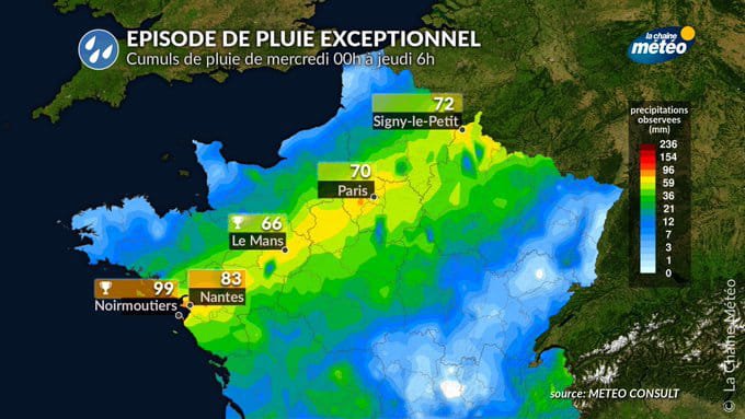
“Storm Kirk will evacuate towards Germany and we will find less agitated weather over France. The clouds will remain numerous, accompanied by showers from the southwest to the northeast. A few strong gusts could still occur early in the morning in the Grand Est region. Mistral and tramontane will rise in the Mediterranean, specifies La Chaine Meteo. At 6:10 this Thursday morning, precipitation readings carried out by Meteo France indicate 80mm at Montigny le Bretonneux (78), 79 mm at Noirmoutier (85), 73 mm at Nantes (44), 70 mm at Paris-Montsouris (75) and it fell very locally 120 to 130 mm on the Alpes Maritimes.